How to get there
This time we wanted to make sure we got the good roads and not the tiny “shortcuts” that could get us into trouble. Overall, we’re talking 260km to cover, so we wanted to keep it as efficient as possible, so we sticked to the main roads. Only a limited part of it is bumpy; most of them are ok. Although, Ugandans love the speed bumps, so even on the wider and decent roads, they have a lot of ‘m, slowing you down.
The last 15km before the park’s Kichumbanyobo gate, a sign indicates where to go. They are building a new registration office – for now it’s a pretty small one for the largest National Park in Uganda and was surprised to see that the toilets were also the least “developed”. Registration – as always – wasn’t the most efficient, but ok. Also here we bought a map of the National Park (this time for 35.000 shilling) to get a better sense of scale and to confirm the tracks we wanted to cover.
The construction works that are going on all throughout the park are hard to miss. The main road is huge – clearly a lot of trees have been cut to make this happen. And we heard from people working in the hotel that they were going to extend the works to other sides of the park too. Because of it – of course – a lot less animals are being spotted from the main road. And everywhere you see Chinese trucks and signs – a kind of partnership in view of the oil extraction, we learned. Because that’s where these huge roads are for: to make the transportation up and back more convenient. All for the money…
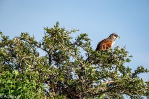
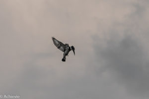
Next to the construction work, you’ll also see baboons all over the place. They don’t seem to be bothered by all the trucks. Another encounter on our way to the lodge, once arriving in the park, was with the tsetse flies. We had heard and read about them, but so far weren’t really bothered by them. Now we knew what everyone was talking about. It was crazy – even crazier than the attack of the birds in Queen Elisabeth National Park we had one of the days before. Didn’t even know, but tsetse flies are apparently attracted by the colors black and blue. And our care is blue… What started with one fly bothering me as it flew inside the car, through the open window, followed by another at my husband’s side, soon turned into an invasion of flies. The bad part is – I’m not even exaggerating – when looking behind on the spare wheel at the back of the car, it was covered with tsetse flies. And so was the front. My husband in the meantime was smacking down flies that were still in the car with our booklet – it was mayhem! So, instead of going for a relaxing drive and looking for wildlife, we just drove quickly further, windows up, until we arrived at the lodge…
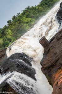
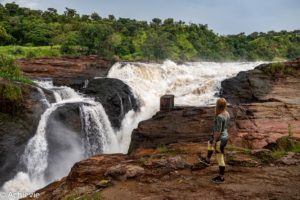
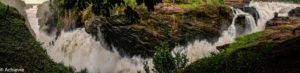
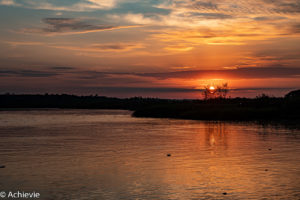
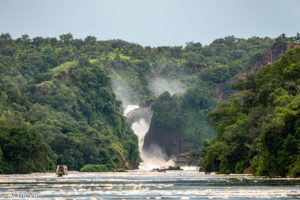
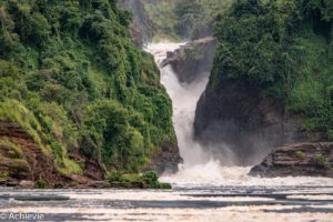
Top of the Falls lookout over Murchison waterfall
Doing this lookout at the end of the day that we arrived in the National Park was ideal. It’s only a 20 min drive from the lodge and it’s recommended to do so in the late afternoon, when the sun is standing lower and the light is getting better for pictures.
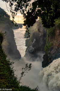
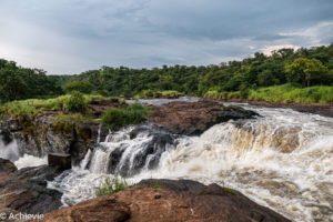
I’m not a waterfall enthusiast, so wasn’t expecting much. But it turned out to be better than anticipated. It’s not your ordinary waterfall and you look at it from up high instead of from down below, so that’s different. And there an enormous amount of water cascading down, causing a giant mist of water that seems to extend for tens of meters. And with the sun setting at the horizon, framed by both side walls, It’s a pretty unique sight.
So, I can confirm the recommendations of going to this lookout. We didn’t do the hike down the waterfall (or up). This trip costs 15 USD (as you need to do this with a guide), but we didn’t really see the point in doing so.
Be cautious on the slippery rocks – we didn’t have our hiking shoes on and felt a little uneasy. Although we saw tsetse fly nets hanging around, we didn’t see any except for one or two on the parking lot. Finally, be aware of when it has rained. The roads to this lookout are new, but I guess (hope) they aren’t finished yet, as they had gotten pretty muddy and slippery after the rain.
Game drive on the North bank of the Victoria Nile river
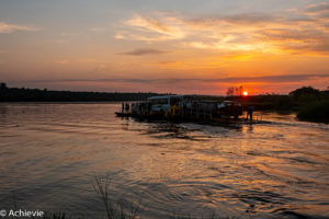
Getting from the South to the North bank by Ferry
Another early wake-up at 5am, to get to breakfast at 5.30 so that we could leave a little before 6am, to be in time for the ferry to take us from the Southern to the Northern bank at 7am. As it’s a 30min drive from our lodge to the ferry and given the limited number of tourists that we had seen so far, we expected to be the first ones there. Imagine our surprise when we saw at least 9 other vehicles lined up before us. When we saw the ferry itself, we soon realized we weren’t going to make it, as it only allows about 6 yo 8 vehicles at a time (depending on the size). We were anxious that we would need to await the next one, leaving at 8am. Luckily that wasn’t the case – once the ferry had made it to the opposite end, it would turn back and load the next batch of vehicles. The first ferry left even before 7 am and one way only takes about 5min, so we were in the ferry by 7.15am. No harm done.
The registration and payment of the ferry fee is done upfront, at the gate and went pretty smoothly. As we also wanted to do the boat tour to the Murchison Falls and back in the afternoon, we immediately booked that one as well, so we were sure to make it. You can also book a similar boat tour with Wild Frontiers (also on the South bank), of which the office is located just passed the UWA registration desk (and gate). Or you can book at the Paraa Safari Lodge on the North bank. As we were staying on the South bank, it’s better to book with one of the 2 operators there, so you don’t have to wait for the ferry to get you back to the other side. And you’re in first, so you can chose a better spot. On the other hand, you’ll need to take the ferry back anyway and given that we wanted to do the boat tour at 2pm, the last ferry we were able to take from the North to the South bank, to make it in time was the one of 12pm. So bottom line, you always need to wait some time anyway. But as we again couldn’t make the first ferry back at 12pm, we only got back to the South bank at 12.30pm, which left just enough time to have our lunch boxes with a few cold drinks on the terrace of the Wild Frontiers building, overlooking the river.
Game drive tracks
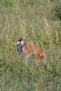
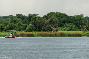
One arrived at the North bank, it’s straight ahead for about 8km, until you get to an intersection on which you have to go left to the airstrip. The map is correct on this part (except for the indication of the airstrip). Following the airstrip road, you’ll get to the intersection where you can chose to go for the Albert track (which we had read is less interesting in game viewing and has tsetse flies). The Queen’s track would be the preferred one, so that’s the one we took. It ends up in Kob leks. Then we went down to Delta and back up to Hippo point. By then it was already close to 11am. Suddenly we saw the patas monkeys in the higher grasses and stopped to try and get a few good shots – not easy!
We wanted to go back through Victoria track, but couldn’t immediately find it (again!), so took the Queen’s track back again. We were at the ferry at about 11.45am, after being held up by giraffes and hartebeest crossing the roads in front of us and a troop of baboons not wanting to move. Still plenty of time for the ferry to take us back.
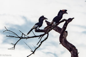
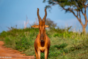
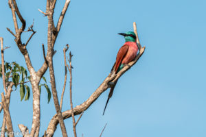
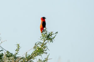
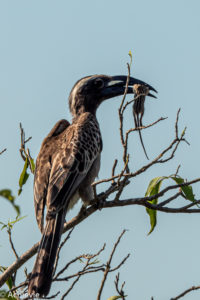
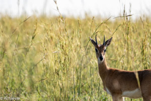
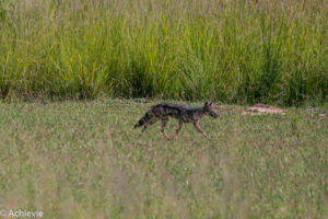
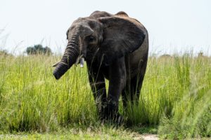
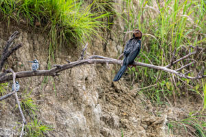
On this morning game drive we saw hornbills, giraffe, hartebeest, Ugandan kob, oribi, warthogs, elephant, jackal (our first and only predator this vacation!), buffalo, hippo and – right at the end – patas monkey.
Boat cruise to the Murchison Falls and back – or not?
So, we had booked the boat the trip at 2pm, which left from the South bank on time. Then went over to the North bank to pick up other passengers until the boat got fully packed. Not too many wiggle room to change positions, depending on what’s coming up on each side of the boat. This doesn’t seem to be different from the other boats we’ve seen.
The trip takes 3 hours. I thought that we were going to stay alongside the bank to watch the wildlife from up close. As the boat is a double decker and the lower deck is sitting quite low to the surface of the water (lower than the one we took in Queen Elisabeth National Park), it looked perfect to get the best views of the animals. But we didn’t go close to the bank at all. Most of the time was actually spent in the middle of the river, focusing on the ride to the waterfalls. We could see some animals, like waterbuck, elephants, buffalo and giraffe, but all from pretty far away. And only for about 1/2 hour in each direction. The main goal of the trip is clearly the waterfall, but then again you don’t go to close to it – which as such makes sense, there’s a lot of power coming from it. But that just made this trip not rewarding at all. Almost no wildlife from up close and a waterfall from pretty far.
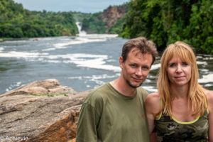
After they dropped off travellers who were going to hike up to the waterfall (the viewpoint that we went the day before), we went a little bit further and the boat stayed there a while for everyone to take pictures, including standing on the deck and getting yourself into the picture. As you’ll see below, the result isn’t that fascinating. The waterfall is pretty small in it.
So, all in all I wasn’t really impressed by this trip and wouldn’t recommend it. The other option is to take a boat trip to the Delta, which they say is rewarding for bird watching. As we’re not bird enthusiasts, that’s why we didn’t take that one, but with hindsight this could have been the better option.
Honeymoon Game Drive Track – or not?
On the morning of our last day, we still wanted to do something. We would be in the car making our way back to Entebbe airport for over 5 hours, so wanted to get the most out of our morning. After studying the map and considering the limited time available to us, we decided to try the Honeymoon track on the Southern bank, very close to Sambiya River Lodge (add link)where we were staying. It leads into Kob Leks as well. The map noted that the condition of the roads needs to be checked upfront, but that seemed to refer to the right part of the tracks, not the one that we wanted to do. The idea was to go to the Kob Leks and then turning back through Burongi Road. That would be just enough to spend the extra hours. The map said open viewing and a newly re-opened track, so should be fairly easy and sounded rewarding as well.
The Honeymoon track itself (first part before the Kob Leks) is very dense. High grasses on both sides, so literally nothing to see. We only saw a bunch of squirrels crossing over the narrow road. At one point a warthog – that’s it. And there was no chance to open any window, as the tsetse flies were back and having a ball infesting our car. As the sun was warming up the late morning pretty quickly, it soon became uncomfortably hot in the car.
Finally we arrived at the Kob Loop and after a while that was indeed offering better views. We saw the usual suspects: Ugandan Kob (lots of ‘m), Hartebeest, warthogs and buffalo. No pictures though – thanks to the tsetse flies.
After the Kob Loop there’s a sign of a Lion Loop – nothing on the map though. Certainly not a loop – a one-way road, yes – but not named “Lion Loop” on the map. As we didn’t wanna risk anything, we didn’t take that one and just continued to the south. After a while we saw a sign showing directions to the Murchison Falls on the one hand and Mansebi on the other hand. The latter one seemed to be the right one. But it was so overgrown. At certain times you didn’t even see the road – it was just all plants, bushes and high grasses. Here and there a tree had fallen onto the road, requiring us to go around it through the high grasses. Luckily the roads weren’t too muddy here…
But that would change. As we turned up to Rabongo Road, a sign confirmed the right direction, but also indicated the need for a 4×4. We had one, of course, but this was the first time we saw a sign indicating this. And we’ve had some rough roads to navigate already, so was kind of anxious when I saw this one. But there was no turning back now, so we just decided to go for it. Not much further, a first large mud pool was showing up. It took a lot of wiggling, shifting gears, slipping away and finding back traction before we got out – my heart stopped a few times. We were in the middle of nowhere, on a track that was clearly not used a lot and we didn’t have all the time in the world, with a plane to catch in the evening. Our car’s battery had given up already a few days before, so were we pushing it? But how could we know? We had an even larger mud area coming up a little later, which was even tighter. Man, was I relieved when we made it through that one as well. It would still take us about 10km before getting on the main road, so I was crossing my fingers the whole time until we got on steadier grounds.
So would I recommend this track? Not really – mostly because of the bad roads and maybe even more because of the tsetse flies – they ruin everything. And we didn’t see anything that we haven’t seen on the Queen’s track (only less).
Other Countries we visited
Have a look at the other countries we ‘achievied’ to visit, and other Achievies…


