The Overland Track is one of the most famous multi-day hikes and is located in the Cradle – Lake St Clair National Park. Wanna give it a try? Here’s our experience…
Before you go
Check this website for all practical details. We also ordered the Overland Track Guidebook, which holds a lot of practical details on the track, but also the types of vegetation and wildlife that you can encounter as well as the history of the place. Finally, you will also definitely need the Overland Track map.
Before starting this adventure, a few other things you need to do:
- Prepare your trip in detail from day to day – the above information will help you do that. Consider your physical health and fitness level
- Make sure you got the right gear. There’s an abundant checklist in the Guidebook referenced above. Everyone we have encountered dealing with this track (the people at the visitor centre as well as the transport company getting you to the track and back) stressed the fact that weather can change before you know it, so it’s extremely important that you have the essentials like good sleeping bags which are up for some slightly negative temperatures, thermo wear and so on. The key is to take everything you need, but don’t take too much, as you – quite obviously – need to carry all of this yourself. We were able to get it all in 2 backpacks of around 16kg.
- Get a National Parks permit, which provides you access to all Tasmanian National Parks
- Get your booking for the track itself secured in time. They only allow a maximum number of people on the track each day
- Get the minimum backpack contents checklist completed and signed
- Organise transportation to get you to and from the track (Overland Track Transport). The track only goes one way – from Ronny Creek to Lake St Clair. They came to pick us up at the Best Western hotel in Launceston to drop us off at the Cradle Mountain Visitor Centre and they picked us back up at Lake St Clair to bring us to the Best Western in Launceston again. Of course we left our luggage at the hotel.
As you get to the visitor centre on the day of the track, you need to register and show/provide the documents listed above and then go to the briefing room right behind the counter. There you’re being briefed and get a pass to attach to your backpack and show the rangers along the track as well as a bus ticket to bring you from the visitor centre to Ronny Creek. First a police officer drilled us on the safety precautions. They strongly urge you to hire an emergency beacon device (PLB: Personal Locator Beacon) that you should switch on in case of any emergency (snake bite, broken limp, etc). Apparently this new procedure, incl the checklist, has been put into place because of the alarming increase in emergency interventions the last 6 months.
Day 1 : Ronny Creek to Wildermere hut
- Total distance of 19km
- Total time spent: 6:12h
As we read and heard that the first day was the toughest (the climb on this part of the track is higher than anywhere else in the track), the initial idea was to only go to Watervalley hut, which is about 7km less.
However, Watervalley hut was closed (which we luckily knew upfront), so we had 2 options:
continue to Wildermere hut (and do a part of what we had foreseen for day 2 on day 1) or
Go to Scott Kilvert Memorial hut, which is actually on another route and would require additional time and kilometers. We also heard that the last part to Scott Kilvert is quite downhill (1 hour descent), which of course you have to make up for the next morning.
So, the new plan was to go for option 1, unless we would feel that we would not have enough energy to finish, at the time we needed to make the decision. Luckily we still felt pretty good, so we went for it. I have to say that at Watervelley hut, I really felt a dip – my neck was really hurting from the 16kg backpack and my right knee was starting to feel sore again on the downhills. But this part of the track is generally easy, so if you would need to make the same decision and you know you can go for 20km, then maybe this might help.
I can confirm what they say: the part up to Marions lookout is the toughest. Some steep steps going up. But it doesn’t take too long, so all in all it’s pretty doable. We’ve had more difficult hikes before, that’s for sure.
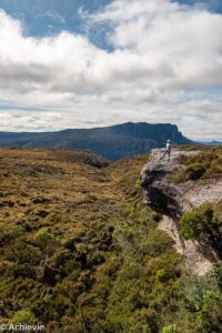
The views along the track are fairly great too. Each turn you take it’s like another mountain or valley is showing up. And the surface of the track is varying as well, which keeps it interesting. Some parts are wooden walkways, others are gravel or dirt and others (the one I least prefer) are rocks in all shapes and sizes.
Of course a lot of the experience depends on the weather you get as well. We were extremely lucky – it had rained all of the day before. When we started, they predicted cloudy with about 40% chance of showers, but it turned out to be quite sunny at times and we haven’t seen a drop of rain all day. That helps of course!
As regards wildlife, we have unfortunately not seen any wombats at Ronny Creek anymore. Along the track a lot of wombat poo, but no sightings. We only ran into a wallaby eating at the toilet area.
The camp site
There’s 16 bunk beds in the back of the hut. The “dining” or socialising area has 4 large tables to sit at. You can gaz cook your meal in the hut. Right outside there’s drinkable rainwater. They advise to clean it first, by boiling or adding a purification solution. We took our chances…
You have to register at each campsite in a diary type of document that is hanging on one of the walls of the hut.
Next to the bunks there are several platforms which can take 2 tents. We opted to use one of these platforms and soon had neighbours. We took our dinner and breakfast in the hut, to keep as warm as we could for as long as we could. The night in the tent itself was colder than expected, despite the fact that we have the proper gear. Even with the sleeping bag in individual mummy shape and with thermo top and leggings and socks on, I was still cold – from 9pm when we were tucked in, all the way to the next morning… Can imagine my mood the next day…
The toilets were amazingly ok. There’s a bin with shaved wood, where you need to take a cup from and cover whatever you’ve left in there, in order to accelerate the fermentation process. There’s no toilet paper, nowhere on the track, so make sure you take that with you.


Day 2: Windermere to Pelion Hut
- Total distance of 16,8 km
- Total time spent: 5:15h
After a bad first night, I needed something to lift me up and I must say that I was quite disappointed about most of this track. I love the buttongrass moorlands which we walked through first – with clear views on the surrounding mountains. But then the vegetation changes to forest and with the remainders of the rainy day 2 days before, it was quite slippery and muddy. A lot of tree roots are sticking out as well as big rocks, which make you jump from one to the other, which is exhausting after about 2 hours. I was relieved to see some open area again after pulling through the forest, which felt like taking forever and ever…
However, we weren’t there yet. Soon we started climbing again, in the forest, over rocks and rocks and rocks… I was happy to see the Old Pelion Hut side track sign showing up – Pelion hut is very close by (less than 1km).
As it comes to wildlife, we have spotted only one wallaby.
The camp site
The site is pretty spectacular. The front of the hut has benches on the porch, so you can take in the wonderful views of Mt Oakleigh and Barn Bluff while recovering from the hike.
Pelican Hut is a lot bigger than Wildermere, in the sense that is has 36 bunk beds. On the other hand it only has 1 larger platform to house several tents. Finally you can also set up your tent on the grassy area.
As I wanted to see whether the hut would be favourable for the temperature during the night and as the tent platform was getting full quickly, we claimed a bunk bed- hoping for a better (warmer) night out in the Tasmanian wilderness… And that proved to be working! You have to trade the cold for the noises your fellow hikers make of course, but nothing some earplugs or headphones can’t solve.
Toilets are similar, although here the smells were a lot less pleasant…


Day 3: Pelion hut to Windy Ridge (Bert Nichols hut)
- Total distance: 18,2 km
- Total time spent: 5h
Again a lot of forest on this track. I enjoyed the Pelion Gap the most – an exposed alpine saddle between Mt Pelion East and Mt Ossa. The side trip to Mt Ossa starts here too. It appears to be a very popular one, as it’s the highest mountain in Tasmania.
From Pelion Gap there’s a descent to Kia Ora hut, which goes through Pinestone Valley and offers views on Cathedral Mountain.
Passed Kia Ora hut, you’re (too) soon back in rainforest. After about an hour you’ll see the first signs appearing for the waterfall side tracks.
As the surface in the forest areas is mainly tree roots and rocks again and considering it’s muddy as well, it can be very tricky at times. Certainly when you’re getting tired and you limbs don’t do what you want them to do anymore – that can get dangerous.
As for wildlife we saw a tiger snake crossing the road, an echidna in a strange position in the bushes and 2 wallabies. A lot of wombat and possum poo, but no sightings. We did see part of a possum tale right on the track, though…
The campsite
Bert Nichols hut has 24 bunk beds. They are different in the sense that they consist of a larger higher and lower platform which each fit several mattresses. So you can get up close and cosy with your fellow hikers, if you would like to…
Next to the bunk beds it also has a few platforms for tents.


Day 4: Bert Nichols to Narcissus hut
Originally day 4 should have taken us from Bert Nichols to Echo Point, where we would have our last overnight before continuing the next morning to Cynthia Bay. However, as we were really getting tired of the same kind of track (forest) and we saw – based upon the descriptions in the Guide – that this would continue all the way to the end (with only limited views on Lake St Clair), we decided to take our chances and try to get the ferry from Narcissus hut to Cynthia Bay.
So we got up at dawn, as most of the other bushwalkers and – after a decent breakfast – started our walk to Narcissus hut as fast as we could. It’s 9km, which we did in 2,5 hours. We were quite rushed, but as such the landscape is pretty similar to the 2 days before. Mainly forest (that’s all you get for the first 5km up to the junction for Pine valley) and at times a short sight of the surrounding mountains (Mt Olympus). With less than 1 km to go before arriving at Narcissus hut, you get nice views on the river.
We spotted one pademelon and saw some wombat poo.
Once arrived at Narcissus hut, there’s a phone that you have to use to confirm any ferry booking, so that’s also the one we used to check and see if there were still 2 spots available on a ferry ride that same day. Believe it or not, but there was! We only needed to wait for 2 hours before the scheduled departure of 1pm. Price for the ferry is 50 AUD per adult.
We then called the Overland Track Transport to see if we could have our ride back to Launceston one day earlier, but that was pushing it… There were still 2 spots open, but a fellow hiker who hurt her knee arrived right before us and got a seat reserved. We didn’t give up, though. We went to the bus stop in time to check if someone would not show up, so we could still hop on. And though I never thought it would be possible, the unimaginable happened and we got on the ride back to Launceston that same day!


Tips
- As mentioned above: make sure you’ve got the right gear (incl basics like toilet paper!) and are prepared for the trek. It’s the hardest one we’ve done so far, mainly because of the heavy backpack. Where we can normally walk to 25km per day, we now had to recognise that this maximum was lowered to 20km and that was already pushing it. Therefore we didn’t do any side tracks. Consider this when planning. They usually foresee at least 6 days (and most other visitors that we talked to did as well)
- What we didn’t bring along and would reconsider is a beanie (mainly to keep warm at night) and tea (to get something hot to warm up after the hike)
- We just took our “regular” backpacks (34 liter) and attached what we couldn’t fit in. Although this worked, it’s not advised. When it’s pouring rain (like it did the day before we started), things will get wet! We were extremely lucky, but as they say the weather is so unpredictable here, it’s not something to count on
- Even though we have sleeping bags which should be able to deal with temparatures right below zero, we were still cold in the tent (even though there was hardly any wind and it was end of summer/ beginning of autumn). So getting a bunk bed secured is what I would recommend
- As they warn you in the briefing as well: try to stick to the former tracks. When you step outside them you’re harming the surrounding vegetation
- Food should be kept in the hut, as otherwise it may attract possum (we’ve heard many stories on the bus!). Point Echo hut is the only exception to this rule, as huge rats like to visit the hut at night
- Talking about food, for breakfast and dinner we stuck with dehydrated food packs which you can find in stores like Paddy Palin, AS Adventure, Aspire and KatMandu. They are very tasty actually and very light weight (around 165 to 180gr for two). There’s various breakfast as well as dinner and even desert options. For lunch we took 2 protein bars per person (+ 1 per person as a back-up for the afternoon).
- Finally, we had also foreseen 2 bags of nut mix, 1 small pack of beef jerkey and a pepperoni salami (which was a left over from the lunch the day before the track).
- Leave your heavy pack at the junctions if you do any side tracks and make sure they are secured. The black curlong birds are after your food when you’re gone, so it’s advised to put your rain cover over your bag and even strap it with core as in the meantime these birds would have learned how to remove the rain cover…
Other Countries we visited
Have a look at the other countries we ‘achievied’ to visit, and other Achievies…